On Friday, February 18th, 2022, US President Joe Biden announced his certainty that Russian President Vladimir Putin had decided to invade Ukraine. Citing US intelligence, the President said that Russian troops would begin their assault on the country immediately – within a matter of days – and that a primary target would be the capital city of Kyiv. His assertion proved correct; Putin’s Russia invaded Ukraine six days later, on Thursday, February 24th.
Geospatial Data as a Basis for Intelligence
How did the intelligence community (IC) know for certain that Putin’s invasion was that imminent? While we cannot know the exact methods utilized to procure the intelligence provided to the President, it is likely that one major type of intelligence was used: geospatial intelligence also known as GEOINT. GEOINT stands alongside HUMINT, SIGINT, MASINT, and OSINT as the major veins of intelligence collection used by analysts across the IC to obtain information and ascertain value and meaning. GEOINT constitutes data obtained from the exploitation of imagery and geospatial information that assesses, describes, and visually depicts features and physical geographies of global activities. The usefulness of GEOINT has never been more apparent than today, and its benefits are being felt widely by stakeholders involved in the current invasion of Ukraine.

GEOINT’s Power
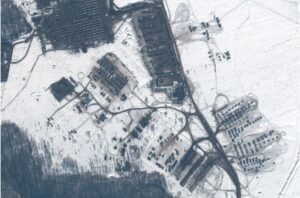
US intelligence analysts very likely used imagery such as this – a picture of Russian troops built up at the Kursk training area near the Ukrainian border with Russia (pictured right) – to arrive at their conclusions. If you are an expert on Russian military installations and vehicles then pictures like this are a goldmine. The technology required to create these images is not necessarily new. But in an age, such as now, when international actors seek to veil their military movements and strategies behind platitudes of propaganda and disinformation, the vitality of these tools has grown immensely.
As such, the prevalence of low orbit satellite technology has also exploded. U.S. Space Command is tracking just under 35,000 objects in low Earth orbit as of August 2021, constituting a 22 percent increase in the last two years. Interestingly, a spokesperson from Space Operations Command reported that the recent leap in the amount of satellites in Earth’s orbit has not been from governments. Rather, the jump is because of the launch of mega constellations, or large groups of small satellites launched by private companies to sell access as a service. In reality, the boom in satellite technology is due to the private sector’s recognition of the dominant role they will play in the future.
GEOINT as a Commercial, Publicly-Available Service
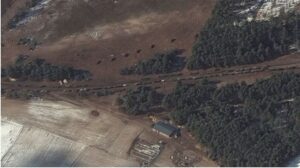
 The image above of Russian forces in Kursk preparing to invade Ukraine was not created by the government; in reality, this image is the product of a satellite owned and operated by Maxar Technologies, a private space technology company based in the United States and serving clients within and beyond the US government. Other private entities offering similar technologies and services include Planet, HawkEye 360, and SkyWatch. Commercially available satellite systems like these have given new technological advantages to actors in the Russian invasion of Ukraine, throughout the duration of the conflict. For example, the satellite image (shown left) from March 11, 2022 shows a convoy of resupply trucks and probable rocket launching equipment just northwest of Kyiv.
This manifestation of GEOINT, also captured by Maxar, may have proven critical to Ukrainian military leaders in planning defenses to counter the approaching convoy. What is so revolutionary about this type of intelligence nowadays is that while its users include government stakeholders, its producers are trending more and more towards the private sector. When intelligence is produced by private companies, it also means that private citizens can gain access to it, as opposed to only government officials operating in a classified, sensitive environment. As covered in past blog posts, publicly available information (PAI) opens up immense opportunities for creative analysis and, above all, ubiquitous knowledge, which Praescient Research Analysts took advantage of to predict developments in the war in Ukraine.
Looking to the Future: An Information-Equal Landscape
Open-Source Intelligence (OSINT) is any intelligence that can be gained through publicly accessible means. So, the commercialization of GEOINT, and thus its marketing towards the general private sector, is making a collision between the two INTs more and more imminent. When GEOINT becomes OSINT, information that has previously only been privately accessible can now be obtained by any interested parties willing to put in a little time and research. This creates a unique challenge for governments and warfighters of the future: how can global actors maintain a competitive advantage on the information front when competitors can easily gain access to what would have formerly been secret? As is the case with Russian forces right now, Ukraine and its allies have been able to exploit publicly available geospatial information to thwart the advantage Russia would have had if their troop buildup had been concealed by a sky clear of satellite technology.
An Equal-Landscape: The Response
How will governments respond? First, countries will integrate space into their national security strategies, as has already been done in the case of the United States, Russia, and China. This means that new technologies will be developed to attack and disable satellite technology, either using cybertools or conventional physical weapons. Defenses will also be increased for these technologies, with a bill currently pending in the US House of Representatives that would accomplish just that.
But given that this technology will grow to be ubiquitous across the major militaries and citizenry of the world, how will governments pivot? In the end, it will all come back to strategy. Military leaders will have to determine ways to take advantage of their physical capabilities even in the face of adversaries having knowledge of them in advance (something that Russia has done a poor job of during their invasion of Ukraine). With the element of surprise being dampened in future military engagements due to the advance of GEOINT technology, countries’ militaries may just be built up even further to compensate. And with everything occurring in the open, militaries might have to resort to increased firepower to get the job done.
When everyone has an information advantage, nobody actually has an edge on their competition.
Here at Praescient Analytics, the increased prevalence and usefulness of PAI-GEOINT sources will further enable us to assist customers with their data analysis needs. From i2 Analyst Notebook’s Google Earth plugin to a number of tools across the ESRI ArcGIS Suite of applications, our technological know-how and analytic tradecraft will continue to evolve and bolster itself as geospatial technologies advance. Click here to discover more about the tools we use to deliver data analysis solutions.